Sectioning The Community Ain't Easy
In Which: A resident pitches a wild idea just for fun. Councilmembers move boundaries in their own neighborhoods. And HARD Draft Maps are revealed.
Council Weighs Public Feedback On Districts
The City Council re-convened in a special meeting on Tuesday to discuss public input on districting and to give the demographers who will draw up the draft maps some direction. The draft maps will be posted on August 27th.
Wild Idea From The Public
The Council chambers were almost empty—not surprising at 5:30 pm on a Tuesday—but one caller gave comment about a map he had submitted that posed an interesting idea. Instead of having 6 districts with 1 councilmember each, the caller proposed having 3 districts with 2 councilmembers in each and using Ranked Choice Voting. They insisted this complies with the California Voting Rights Act (CVRA), citing Albany as an example—though they only used Ranked Choice Voting, not multiple seats per district.
When the topic was considered by Council, however, their attorney pointed out that the settlement agreement called for 6 districts and 1 at-large mayor. Any changes would require further litigation, which the City does not have an appetite for. Ranked Choice Voting could be implemented with a 6 district system another time, however.
Feedback From The Community
The consultants presented the results of the community engagement. Much of the feedback was Communities of Interest (COIs)—mapping out individual neighborhoods. The consultant said many came from an in-person engagement session hosted by the Hayward Community Coalition during the last Downtown Street Party, though they wished there had been descriptive information, as well.
This diversified the COIs available—the majority of the feedback had come from people in the northern Hayward. You can check out the feedback on the Districting website. Unfortunately, the City’s engagement still fell far short of HARD’s—they received a whopping 41 maps before settling on their drafts (more on that below).
The Lawyer’s Mandatory 15 Minutes
Mayor Mark Salinas made a point of calling out Attorney Scott Rafferty’s city of residence, Walnut Creek. Not only it is still using at-large elections, but the Mayor has made clear he doesn’t like the idea of an outsider forcing the districting process. When it was the attorney’s chance to speak, the Mayor called him “Mr. Scott Rafferty, of Walnut Creek.”
The crux of the lawsuit brought by Neighborhood Elections Now Inc (run by Scott Rafferty) and Jack Wu (Hayward resident) has been underrepresentation of the Asian community. “(The Asian community) perhaps deserves priority over neighborhoods to some degree,” Mr. Rafferty said. “Elsewhere, I don’t think you need to think so much about race.” However, even Mr. Rafferty conceded that race alone can’t be the deciding factor. “Constitutionally, you can’t look just at race,” he said.
An idea Mr. Rafferty pitched was trying to align an Asian majority district with the HUSD and HARD districts. “[It would be] nice if the Asian district is somewhat congruent with the school district and HARD,” he said. “It makes it easier for them to organize… Outside the remedial district [Asian district] it’s less important.” He also floated the idea of having some kind of Asian slate for the City, HARD, and HUSD.
An issue with having a district focusing exclusively on race—despite being unconstitutional—is that the Asian community is incredibly diverse. The term Asian American was always a political umbrella term that embraced a wide range of ethnicities. By most definitions it can include poverty-wage Filipino home care workers as well as Maserati-driving Indian tech executives. Including any other demographic information can’t help but fracture the Asian community.
Despite all this, Mr. Rafferty said that the City is “off to a good start.”
The City Council On Districting
The Council weighed in on the public feedback. The presentation hadn’t been posted at the time of writing, but we’ve linked to all of the maps with the number they were given so you can see which ones Council is favoring.
How Do We Talk About Race?
Councilmember Zermeño was one of many Councilmembers who wanted clarification about how race should or shouldn’t be considered. “One of the directions that I heard… is that we aren’t supposed to be making decisions [based] on ethnicity—then why are we discussing Asian presence in some of these districts?” Councilmember Roche was also concerned. “[We’re] not supposed to talk about race, but it’s the predominant reason why we’re districting.”
The consultant reassured them that while race can’t be the only criterion considered, but it can be one of the criteria considered. She also recognized that Hayward is a diverse place with multiple protected groups. “We don’t want to disenfranchise a protected minority group—we have multiple minority groups. We will keep an eye on all of them,” she said.
However, there were multiple Councilmembers who were concerned about reducing the power of the Latine vote. They comprise about 40% of the people of Hayward and, one could argue, are proportionally represented on City Council with 3 of 7 Councilmembers. However, there’s a possibility that districting could dilute their voting power. “In order to sort of promote a community that needs representation,” Councilmember Roche said, “we’re demoting the majority minority in the city and I think that’s a big concern.”
Councilmember Bonilla Jr. agreed with the concerns about the Latine vote. “Some of these maps are really diluting the Latino vote in Hayward,” he said. “Let’s keep the Latino vote together.” The reduction cited by Councilmember Roche was from 40% of the overall City population to as low as 35% in some districts.
My Neighborhood Goes This Way
Some Councilmembers also seemed particularly interested in how their own neighborhoods were represented. Councilmember Roche was the most open about trying to define the Fairway Park neighborhood where she lives. “[The] Fairway park neighborhood is traditionally Industrial Boulevard and South,” she said.
Councilmember Bonilla was also concerned with how a particular neighborhood is defined. “I’m not sure that the people who live directly off Mission, like Belmont or Del Mar—I’m not sure they identify with the hills as much as they do the flatlands.” Although it can be difficult to know exactly where Councilmembers live, knowing side streets by name suggests that this is Councilmember Bonilla’s neighborhood—though he didn’t say so.
Councilmember Goldstein expressed concern for his neighborhood, as well. “Do we have to divide this side of the street from that side of the street?” he asked. He was concerned that certain neighborhoods are unintentionally grouped together over wide open space where he lives in the Garin area. The consultant hinted that it’s possible that the final map will draw lines through open areas as opposed to down the middle of streets.
Councilmembers Goldstein, Andrews, and Roche all live within a half mile of each other as the crow flies, so small adjustments in the Garin/Fairway Park areas can make a big difference. And if Councilmember Bonilla is on the East side of Mission, he could be grouped with the Hills which could include up to 2 other Councilmembers.
The current Councilmembers run the risk of being lumped into the same district. And although districts can’t be drawn to benefit incumbents by law, they could try defining their neighborhoods in such a way as to be separated from each other. However, it’s also possible they’re merely trying to define their own neighborhoods as accurately as possible.
Feedback On The Maps Themselves
Finally, Councilmembers weighed in on which maps they preferred of the public submissions. Below is a list of the maps and who supported each:
Councilmember Syrop was one of the only ones who gave any suggestions that didn’t have to do with his immediate neighborhood. “What I do like about [Map 1 and Map 5] is the structure of Downtown.” But he also had some things he felt should be changed to make the maps better. “I do see some neighborhoods along Mission having more in common with maybe the Triangle in this regard.” In Map 1 the BART tracks are the dividing line between the Jackson Triangle and the Hills districts which lumps in some much poorer neighborhoods with the Hills.
On the subject of income, Councilmember Andrews wanted to know how that mapped to the City. “Have you seen where maps are showing a cross-section of income as opposed to just areas?” Although geography and income are often correlated, there are specific pockets of affluence among poverty due to the recent redevelopment efforts.
Mayor Salinas Goads The Lawyer
When it was his turn, Mayor Salinas had a very different idea of what the districts should be. “[I’m] concerned that we have essentially segregated the hills,” he said. “I thought we’d have East-West lines.” He hoped that having a mix of high and low income residents in a district would get residents to talk to each other and work together more.
Unfortunately, as Mr. Rafferty pointed out, this can actually further entrench the power of wealthy residents. In many ways, poor and affluent people have opposing needs and political desires—at least one member of the Planning Commission has showcased that fact publicly.
Mayor Salinas also wondered why the plaintiff in the case, Jack Wu, hadn’t submitted any maps. Mr. Rafferty started by being visibly angry that the Mayor kept calling out his city of residence, going so far as to compare it to the racism faced by lawyers fighting similar cases in the South. For clarity, Mr. Rafferty is a White man and Mayor Salinas is a Latino/Chicano man.
Mr. Rafferty then explained that his client was waiting to see more input from the public before submitting a map. “We still have six days,” he said. He admitted, however, that his client didn’t submit a map at all for HUSD because he was allegedly satisfied with the maps that came forward.
Mayor Salinas then said that unnamed “proud community members” had told him during National Night Out that they were offended about being forced into districts. It was unclear whether the community members took issue with being forced into the process or were instead against the idea of districts in general. So far only a few people, many of whom explicitly mentioned benefitting from the status quo, have publicly spoken against districts.
Draft maps for the City of Hayward will be posted on August 27th.
HARD Draft Maps Revealed
Although it’s impossible to know what happens at HARD Board meetings without being there, the draft maps have been posted—if quietly.
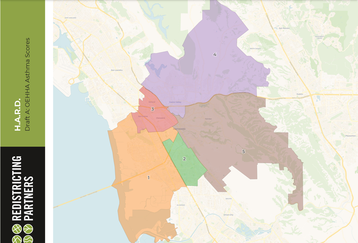
Draft Map A
This map uses health impacts to create the districts. Those who experience similar health impacts, most notably asthma, from being near highways and other industrial areas. It also tried to maintain Hayward neighborhood boundaries, unincorporated places, and the communities of Ashland, Cherryland, and San Lorenzo.
Draft Map B
This map uses Communities of Interest and unincorporated community boundaries to draw the maps. It used roads and railways as boundaries and tried to preserve Hayward neighborhoods, and the communities of Ashland, Cherryland, and San Lorenzo.
Draft Map C
This map used the School Districts to draw the boundaries. HARD is much bigger and includes multiple school districts—Castro Valley, San Lorenzo, HUSD, and some of New Haven. They also, like the rest, tried to keep communities together as much as they could.
I wish I knew what the Board members thought about the maps and what their considerations were—I personally prefer Map B. The HARD board is almost exclusively White with very little representation from Hayward, despite the district being named after the City. Any amount of districting will be good for HARD, assuming they start having elections regularly.
You can learn more details about the maps and give feedback about them on the HARD Districting page. They’re the 3 top-most maps on that page.


